Wildfires Affect More Than Just Air Quality
Wildfires Affect More Than Just Air Quality
If you’ve watched the news lately, or if you live in the Mountain West, you won’t be surprised to learn that wildfires in the United States have been increasing in frequency and intensity over the past few decades. Factors contributing to this trend include prolonged droughts, higher temperatures, and changes in land management practices. Regions in the West, particularly California and Colorado, have seen significant increases in the number and scale of wildfires, impacting ecosystems, air quality, and communities.
Although it isn’t the first thing most people consider when they see billowing smoke, these fires can also impact water resource planning. That’s because fires disturb snowpacks in the mountains.
iSnobal is a model for predicting snowmelt, which is an important practice for many communities. Too much run-off means farmers need to prepare for floods. Not enough means drought. Knowing what to expect ahead of time makes all the difference for finances, businesses, and even health. But fire disturbance can create difficulties when using the iSnobal model.
Charred landscapes absorb more solar radiation, causing snow to melt faster, and the hydrological response of these areas becomes highly unpredictable. This is particularly significant in watersheds where greater than 10 percent of the land area has been impacted by fires. Such disturbances lead to altered snow accumulation, and changes in water runoff behavior.
That’s why M3Works has integrated a novel fire disturbance adjustment into its iSnobal models. This change is essential for accurately predicting snowmelt behavior in fire-affected basins.
The necessity of these fire adjustments became evident after multiple events, such as the Dixie Fire (2021) in California, the Creek Fire (2020), and Colorado's East Troublesome Fire (2020). These fires burned huge portions of critical water basins, affecting water management in the Sierra Nevada and the Rocky Mountains. With up to 40 percent of a basin burned, standard snowmelt models failed to predict the faster and more erratic melt patterns.
The forest canopies, which typically protected snow from direct sunlight, were gone after the fires. Changes in soil structure and vegetation resulted in altered infiltration rates, reducing clean water availability in communities. A better model was needed to help prepare for these kind of ecological disturbances. That’s where fire adjustments came in.
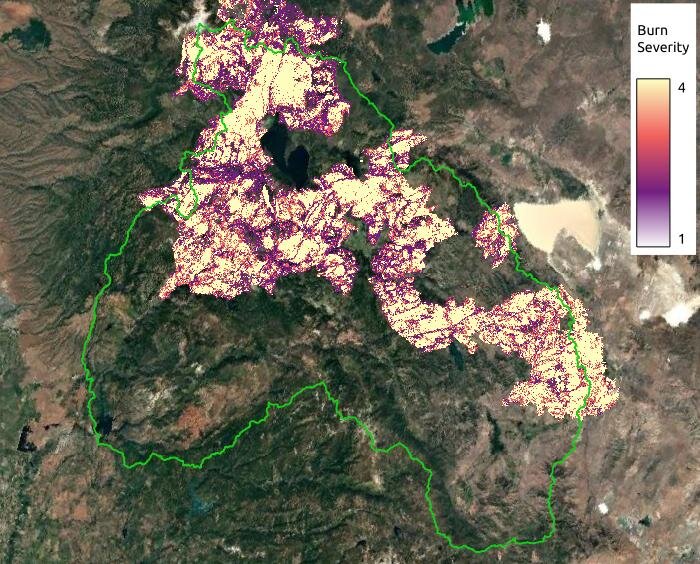
Burn severity for the Dixie and Sugar fires in the Feather River Basin in CA.
Testing the Fire Disturbance Adjustment
M3Works has applied its fire disturbance adjustment to three distinct basins each affected by major wildfires in recent years, including the Dixie Fire and the East Troublesome Fire. In all three cases, standard models underestimated the rate of snowmelt. With the adjustment in place, the models accurately reflected the accelerated melt caused by the lack of vegetation and the altered albedo (surface reflectivity) of the burned areas.
Why Data Validation Is Crucial
For M3Works, the accuracy of these adjustments shows the importance of their continuous effort in data validation. Fire-affected regions are highly dynamic, and snowmelt behavior can change dramatically year-to-year, even after the immediate effects of the fire have subsided. You can’t simply adjust one time and then assume it will be accurate for years to come. Ongoing validation allows M3Works to fine-tune the adjustments, ensuring that their models reflect the latest conditions in the field.
One of the ways they validate their data is using LiDAR technology from the Airborne Snow Observatories, Inc. LiDAR stands for "Light Detection and Ranging." It is a remote sensing method that uses light in the form of a pulsed laser to measure distances and create detailed three-dimensional maps of the Earth's surface and features. The light pulses are sent from an aircraft flying over basins. The ASO Inc measurements give M3Works accurate data about snow depth, reflectivity, and forest height.
For more information about M3Works’ data validation process, read these two articles:
Enhanced Validation of the iSnobal Model
M3Works' Rigorous Validation Process
M3Works’ fire disturbance adjustment is a vital tool for understanding and predicting water resources in agricultural, municipal, and environmental systems. By integrating this knowledge into their models, M3Works ensures that clients receive the most accurate predictions possible, enabling clients to make more informed decisions about their futures.
Micah Johnson is a software developer, mechanical engineer, and scientific modeler. His career began with building models capable of studying advection through snow grains which ultimately got him hooked on the world of snow science. Since then, he has built a variety of software tools for streamlining common Geoscience tasks, developed a spatial database for holding the NASA SnowEX data, and developed novel snow instrumentation for measuring snow microstructure. As a co-founder of M3 Works, Micah spends his time developing methods to set up new basins and expand our model validation packages.
- M.S. Mechanical Engineering
- 11 years scientific modeling
- 10 years development experience

Solutions
Company
Resources
© 2024 M3Works. All rights reserved.